Why in news?
India’s weather agency is implementing a new digital forecasting platform called the Multi‑Hazard Early Warning Decision Support System to improve preparedness for extreme weather events. The platform, developed under the Mission Mausam programme of the Ministry of Earth Sciences, has recently been credited with reducing casualties during major cyclones and floods. On 3 April 2026 it was highlighted for helping authorities issue timely alerts and for integrating data from numerous sources to give longer lead times.
Background
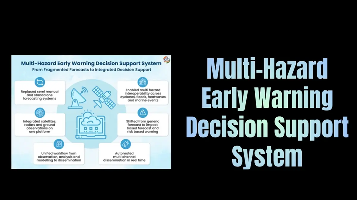
Before this system was created, weather forecasts in India were generated separately for different hazards—rainfall, cyclones, heat waves and fog—using manual processes and limited data assimilation. The lack of integration meant that warnings were sometimes delayed or inconsistent, and local officials had to interpret complex meteorological data without sufficient tools. In November 2022 the India Meteorological Department (IMD), under the Ministry of Earth Sciences, began developing a unified decision‑support system to bring together atmospheric observations, satellite and radar images, and numerical weather prediction models. The platform was launched in January 2024 and has been fully operational since August 2023. It aligns with the government’s digital governance initiatives and is designed to support 70 forecasting offices across the country.
Features and operation
- Integrated data assimilation: The system collects about 90 percent of its observational data automatically through satellites, radars, ocean buoys and automatic weather stations. It assimilates this information into a unified database and runs multiple numerical models to generate consensus forecasts.
- Longer lead times: By harmonising outputs from different models, forecasters have increased the lead time for public warnings from five days to about seven days. Faster processing also shortens the time between data collection and forecast dissemination.
- Hazard‑specific modules: Separate modules analyse tropical cyclones, heavy rainfall, heat waves, thunderstorms and fog. Each module combines real‑time observations with model output to provide location‑specific risk assessments.
- User‑friendly interface: An online dashboard allows district officials, disaster managers and farmers to view risk maps, rainfall probabilities and wind forecasts. The system automatically generates decision‑support products such as colour‑coded warnings and recommendations for evacuation or school closures.
- Multi‑channel dissemination: Alerts and advisories are delivered via text message, television, radio, social media and the IMD’s mobile app. An audit trail ensures transparency in decision making.
Impact and significance
- Saving lives: During cyclones Biparjoy and Dana in 2023 and subsequent storms in 2024–25, early warnings issued through the system helped state governments evacuate vulnerable communities well in advance. Officials credited the platform for reducing casualties to almost zero during these events.
- Economic benefits: Better forecasts allow farmers to plan crop operations, fishermen to avoid dangerous seas and power utilities to manage supply and demand. Early warnings also reduce property damage by giving more time to secure infrastructure.
- Scalable and replicable: The architecture is modular, allowing states and neighbouring countries to adopt the system for local use. It can be expanded to include river‑flood forecasting, landslides and other hazards.
- Transparency and accountability: Automated data collection and digital record‑keeping minimise manual errors and provide clear evidence for post‑disaster reviews. The system aligns with India’s broader push for data‑driven governance.
Conclusion
The Multi‑Hazard Early Warning Decision Support System represents a significant step forward in India’s disaster preparedness. By unifying data streams and automating workflows, it equips forecasters and officials with timely, actionable information. Continued investment in such digital platforms will help India build climate resilience and protect lives and livelihoods as extreme weather events become more frequent.
Source: PIB

