
Why in news?
An international science team is sailing towards Greenland. Its six-week mission begins on 16 July 2026. Researchers will study how glacier melt affects North Atlantic circulation. The findings may improve warnings about dangerous climate thresholds.
Background
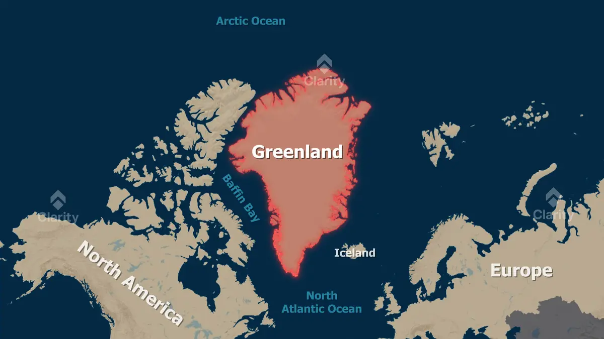
Greenland is the world’s largest island, excluding continents, and it lies mainly within the Arctic Circle.
Geographically, Greenland forms part of North America, and politically, it is a self-governing territory within the Kingdom of Denmark.
Its capital is Nuuk, and most residents live along the ice-free coast, especially in the southwest.
The island covers about 2.166 million square kilometres, and ice covers roughly four-fifths of this area.
Greenland’s ice sheet is the world’s second-largest ice body after Antarctica. Its area is about 1.71 million square kilometres.
Political status: Greenland is not an independent country or a Danish province. It is a self-governing territory within Denmark’s kingdom.
How did Greenland’s present status develop?
- Inuit peoples settled Greenland through several migrations over thousands of years.
- Norse settlements appeared along the southern coast around the year 985.
- Denmark-Norway later renewed colonial control during the eighteenth century.
- Denmark retained Greenland after its union with Norway ended during 1814.
- Greenland became an integrated part of the Danish realm during 1953.
- Home Rule began after a referendum and took effect during 1979.
- Greenland left the European Economic Community during 1985.
- The stronger Self-Government arrangement took effect during 2009.
Denmark remains a European Union member, but Greenland is outside the Union. Greenland manages most domestic policy areas.
Denmark retains responsibilities concerning defence and much foreign policy, and Greenland’s people also possess a recognised right to self-determination.
Where is Greenland located?
- The Arctic Ocean lies towards its north.
- The Greenland Sea lies towards its east.
- Baffin Bay and Davis Strait lie towards its west.
- Denmark Strait separates Greenland from Iceland in the southeast.
- Nares Strait separates northwestern Greenland from Canada’s Ellesmere Island.
Gunnbjørn Fjeld is Greenland’s highest mountain, and its accepted elevation is about 3,694 metres.
Why does the ice sheet matter globally?
Snow accumulated over many centuries and compressed into thick ice. Gravity slowly moves this ice from the centre towards the coast.
Outlet glaciers carry inland ice into fjords and the ocean, and they lose mass through surface melting and iceberg calving.
Greenland’s melting adds water directly to the ocean, and it therefore raises global sea levels.
Complete melting would raise average sea level by about 7.4 metres. This is a physical equivalent, not a near-term forecast.
Fresh meltwater can also change the North Atlantic’s temperature and salinity, and these properties help drive major ocean circulation.
What is the new research programme?
The five-year project is called Greenland Ice Sheet to Atlantic Tipping Points. Its short name is GIANT.
The British Antarctic Survey leads seventeen partner institutions, and seven participating organisations are based outside the United Kingdom.
The United Kingdom’s Advanced Research + Invention Agency provides funding, and the programme has a budget of about £20 million.
Project work runs from April 2025 through March 2030, and its first major ship campaign begins in July 2026.
About eighty scientists and crew will use the Royal Research Ship Sir David Attenborough. The expedition will last six weeks.
Which places will researchers study?
The 2026 mission focuses on Kangerlussuaq Fjord in southeastern Greenland, and several fast-changing glaciers discharge into this complex fjord system.
A contrasting campaign will examine Petermann Glacier in northwestern Greenland during 2027. Comparing sites helps separate local and wider processes.
How are glaciers and ocean circulation connected?
The North Atlantic Subpolar Gyre circulates water around the northern Atlantic, and Greenland meltwater enters this broad circulation system.
Another larger system is the Atlantic Meridional Overturning Circulation. It is commonly shortened to AMOC.
Warm, salty surface water moves northward, and cooling increases its density and helps some water sink.
Cold deep water then returns southward, and this movement carries heat, carbon, oxygen and nutrients between ocean regions.
Fresh meltwater contains less salt and is less dense, and a surface layer can make deep sinking more difficult.
Scientists expect the circulation to weaken as climate changes, but the size, timing and consequences remain uncertain.
Do not confuse: The Atlantic overturning circulation is not identical to the Gulf Stream. The Gulf Stream is partly wind-driven.
What is a climate tipping point?
A tipping point is a critical threshold, and beyond it, self-reinforcing changes can push a system towards a new state.
Crossing a threshold does not always cause an instant visible collapse, and changes may unfold across years, decades or longer.
The expedition will examine risks and early warning signals. Its departure does not prove that an overturning collapse is imminent.
Which instruments will the mission use?
- Satellites and drones will map surface change across large areas.
- Meltstake will drill into submerged ice about one hundred metres below the surface.
- DriX, a surface robot, will map underwater terrain with sonar.
- Gavia and EcoSubs will swim near the glacier’s submerged front.
- Boaty McBoatface will travel beneath difficult ice-filled waters.
- Adios radar will monitor motion and structures within the glacier.
- Geopebbles will record position and seismic movement on the ice.
Boaty McBoatface is an Autosub Long Range autonomous underwater vehicle, and it is not the expedition’s research ship.
The vehicle can dive roughly 1,500 metres beneath ice mélange. It records water properties where crewed ships cannot safely travel.
Ice mélange is a dense mixture of sea ice, snow and iceberg fragments. It can temporarily brace a glacier front.
When this mixture breaks apart, the glacier may calve more rapidly. Researchers need simultaneous ice and ocean measurements to trace that connection.
What will happen to the data?
Scientists will combine field observations with satellite records and computer models, and this approach links small processes with regional consequences.
The results will improve the United Kingdom Earth System Model. That model represents interactions between air, oceans, ice and ecosystems.
The project also seeks a prototype early warning system. Such a system would identify meaningful changes before severe consequences develop.
Conclusion
Greenland connects glacier loss, sea-level rise and ocean circulation, and direct measurements can turn broad concern into better risk estimates.