
Why in news?
A new study estimated a steep fall in Gulf shorebirds. Modelled abundance declined about fifty-seven per cent over four decades. Repeated survey sites showed an even larger fall. Researchers examined forty species across four non-continuous survey periods.
Background
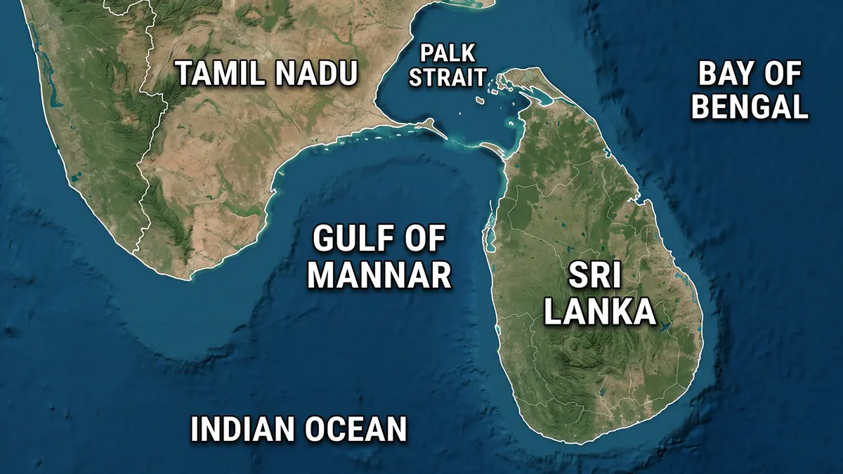
The Gulf of Mannar lies between southeastern Tamil Nadu and western Sri Lanka. It forms part of the Laccadive Sea.
Rama Setu, also called Adam’s Bridge, lies to its northeast, and this chain separates the gulf from Palk Bay.
The Thamirabarani and Vaippar rivers enter from India, and Sri Lanka’s Malvathu Oya also drains into the gulf.
Thoothukudi is the major Indian port on this coast, and the gulf supported ancient pearl, chank and maritime trade.
Why is the gulf biologically important?
Its shallow coast contains coral reefs, seagrass beds and mangroves, and mudflats, salt marshes and lagoons add further habitat variety.
These habitats support thousands of marine and coastal species, and dugongs depend upon seagrass meadows for food.
Coral reefs shelter fish and reduce wave energy, and mangroves protect shorelines and provide nurseries for young aquatic animals.
Mudflats expose worms, molluscs and other prey during low tide, and migratory shorebirds depend upon this predictable food supply.
How did legal protection develop?
- The Gulf of Mannar Marine National Park was notified during 1986.
- It protects twenty-one islands and surrounding waters.
- The protected marine area covers roughly 560 square kilometres.
- The wider biosphere reserve was declared in 1989.
- Its area is roughly 10,500 square kilometres.
- The global biosphere network recognised it in 2001.
The biosphere reserve is widely recognised as India’s first marine biosphere reserve. It combines protected cores with surrounding human-use areas.
However, it was not India’s first marine national park, and the Gulf of Kutch received that distinction earlier.
Prelims distinction: Gulf of Mannar is India’s first marine biosphere reserve. Gulf of Kutch had the first marine national park.
What did the new shorebird study examine?
The study appeared in Regional Environmental Change on 15 June 2026, covering change across roughly four decades.
They used four non-continuous periods, and these were 1985-1988, 2005-2007, 2018-2019 and 2021-2024.
Survey locations included Dhanushkodi, Pillaimadam, Manoli Island and Valinokkam lagoons, and together, the records covered forty shorebird species.
The team standardised peak seasonal counts before modelling trends, and standardisation improves comparison when survey effort differs between periods.
What were the main findings?
- Overall modelled abundance fell about fifty-seven per cent.
- Repeatedly surveyed locations showed about seventy per cent decline.
- Roughly sixty per cent of regular species fell by half.
- Major shifts appeared around 1987-1988 and 2021-2022.
- Siberian Sand Plover numbers showed a strong decline.
- Curlew Sandpiper numbers also fell sharply.
- Kentish and Greater Sand Plovers increased in the records.
- The latest period added six previously unrecorded species.
The Hanuman Plover was among recent additions, and new appearances do not cancel large declines in total bird numbers.
How can species richness remain stable during decline?
Species richness means the number of different species recorded, and abundance means the total number of individual birds.
A site can retain forty species while hosting fewer birds of each. Stable richness therefore does not prove a healthy population.
The study found about 29.7 per cent turnover in species composition. Turnover measures replacement between earlier and later species lists.
Do not confuse: More species on a list does not mean more birds, and richness and abundance answer different questions.
What may be driving the changes?
The study linked declines with habitat modification and human pressure. These relationships remain likely explanations, not proof of one cause.
Roads and visitor activity increased around Dhanushkodi, and disturbance can interrupt feeding and force birds from high-quality mudflats.
Mangrove expansion near Manoli reduced some open feeding areas, although mangroves remain valuable habitats.
Pollution, fishing pressure and coastal construction can alter prey, and sea-level rise may squeeze mudflats against hardened shorelines.
Valinokkam’s man-made lagoon provided supplementary habitat, and it did not explain the entire gulf’s long-term change.
What are the study’s limitations?
The surveys did not run continuously every year. Long gaps can hide short-term rises, crashes or changes in survey conditions.
Researchers used standardisation and statistical models to reduce these problems, and the estimated percentages still carry uncertainty.
Migration also depends upon distant breeding and stopover sites, and local counts can fall because problems occurred elsewhere.
What is the Central Asian Flyway?
A flyway is a broad route used by migrating birds. The Central Asian Flyway links northern breeding areas with southern wintering grounds.
India lies near the centre of this route. Its wetlands feed birds travelling between Arctic regions and the Indian Ocean.
Loss of one important stop can weaken the whole journey, making international cooperation essential for migratory-bird conservation.
What should conservation prioritise?
- Long-term annual counts should use consistent methods.
- Important mudflats need protection from avoidable disturbance.
- Tourism and roads require strict coastal planning.
- Pollution sources should be identified and reduced.
- Restoration should preserve a mosaic of habitats.
- Fishing communities should help design workable protections.
- Regional data should connect India with other flyway countries.
Conservation should not convert every open mudflat into mangrove, and the correct habitat must be restored at the correct site.
Conclusion
The decline signals stress across a globally important coast, and continuous monitoring and balanced habitat protection can guide timely recovery.