

Why in news?
Pilibhit Tiger Reserve's tourism season is to run from 1 November to 30 June, according to a 21 September 2026 report. The Press Trust of India account quoted Uttar Pradesh wildlife officials announcing the change. The usual season had run from 15 November to 15 June. The reserve protects a Terai landscape of sal forest, grassland and wetlands near India's border with Nepal. A longer visitor season could support tourism activity, but it also requires careful management of routes, weather and disturbance. The announcement changes the tourism calendar; it does not mean unrestricted access to every part of the reserve.
Locate the reserve before describing its wildlife
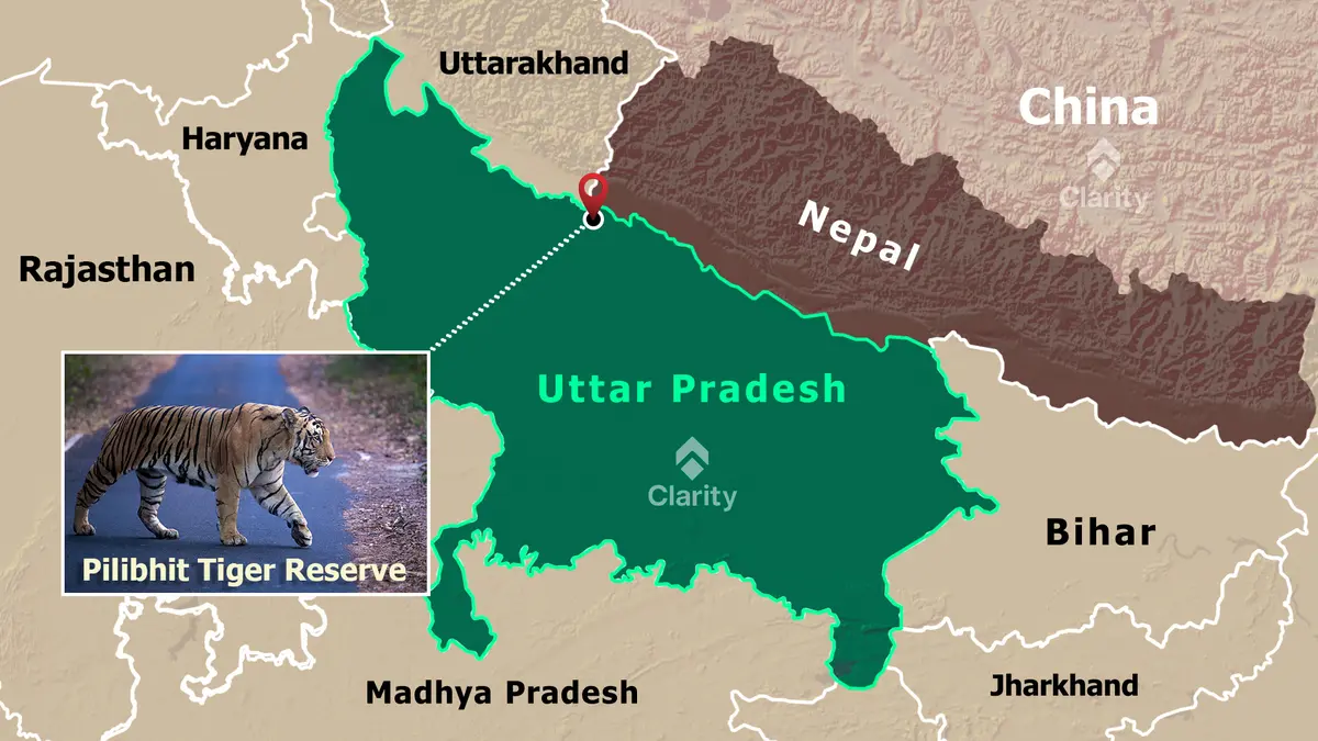
Pilibhit lies in northern Uttar Pradesh's Terai, along the Himalayan foothill belt and upper Gangetic plain. This is a lowland landscape influenced by rivers, wet ground and seasonal flooding. Its location helps explain the combination of sal woodland, tall grass and swampy habitats. These adjoining environments provide different forms of cover and feeding space within the same wider wildlife landscape. The interaction between water and vegetation is central to understanding the reserve's ecological character.
The National Tiger Conservation Authority (NTCA) describes a reserve area of approximately 730.25 square kilometres. That includes about 602.80 square kilometres of core habitat and 127.45 square kilometres of buffer. The distinction matters because a tiger reserve is not simply a single visitor zone. Conservation priorities and permitted activities differ across its management units. Quoting the total area as though all of it were open for tourism would therefore give a misleading picture.
A reserve connected to forests beyond its boundary
The NTCA's reserve profile places Pilibhit within a network of neighbouring habitats. Connections run towards Kishanpur and the Dudhwa landscape, and towards Nandaur. On the Nepal side, the Lagga-Bagga area connects towards Shuklaphanta. These links make the reserve more than an isolated patch of forest. Animals moving between habitats can encounter roads, agricultural land and settlements along the way. Conservation planning therefore cannot end at the administrative boundary of the protected area.
The Sharda Sagar reservoir is another important feature of the reserve's setting. Water, floodplain vegetation and adjoining woodland shape where wildlife feeds, shelters and moves. A map showing only the tiger reserve outline misses those relationships. The practical geography includes the river-and-reservoir setting, the Nepal border and the routes connecting neighbouring forests. Maintaining those relationships is different from simply increasing the number of animals seen from a safari vehicle.
Why habitat variety matters
Sal forest and grassland do not perform identical ecological functions. Woodland offers shade and cover, while grasslands support feeding opportunities for herbivores that form part of the tiger's prey base. Wetlands add another set of habitats within the mosaic. The conservation task is therefore not to convert every open patch into dense tree cover. It is to understand which habitats belong in the landscape and how their condition supports wildlife over time.
That perspective also changes how tourism success should be judged. A popular sighting can be memorable, but it does not measure the condition of grasslands or the safety of a movement corridor. Visitor numbers likewise cannot substitute for ecological monitoring. These are related activities with different purposes. Tourism allows people to experience the reserve, while habitat management must sustain wildlife throughout the year, including periods without visitors.
What changes in the visitor calendar
The reported decision brings the opening forward by a fortnight and extends the closing into late June. Officials also referred to preparations involving safari routes and facilities around Chuka. The announcement indicated higher weekend charges, although no complete ticket-price schedule was given in the cited account. Visitors would need the applicable booking rules and official operational notices for their chosen date. A published seasonal window is not a guarantee that weather will permit every scheduled trip.
For local guides, transport operators and accommodation providers, a longer season may create additional opportunities. That is a potential benefit, not a verified increase in earnings from a season that has not yet occurred. Its distribution would depend on bookings, access arrangements and local participation. Conservation and livelihood goals are most useful when discussed together, without assuming that either automatically follows from adding more days to the calendar.
Tourism must fit the conservation plan
The NTCA's tourism guidelines place tourism planning within the wider Tiger Conservation Plan. They also require attention to carrying capacity: the level and pattern of visitation that an area can accommodate. This is not only a count of available vehicles. Route conditions, wildlife disturbance and the way visitors are distributed can all affect management choices. Extending the calendar should therefore be accompanied by practical review of where and how access remains appropriate.
Seasonal decisions are especially important in a landscape influenced by water. A route suitable in one part of the year may require a different decision when ground conditions change. That does not mean every extension is harmful, or every closure sufficient. It means that operational choices should respond to observed conditions. Clear rules, enforcement and communication help avoid turning a general tourism announcement into pressure to operate regardless of local circumstances.
Conclusion
Pilibhit's longer tourism season is a change in visitor management within a larger conservation landscape. Understanding it requires attention to the Terai's habitats, the reserve's core and buffer, and links with neighbouring forests and Nepal. The useful test is whether additional access remains compatible with those ecological relationships and benefits nearby communities responsibly.