
Why in news?
Yemen’s Houthi movement announced a maritime blockade against Saudi Arabia. Its warning again raised shipping risks near Bab el-Mandeb. Saudi Arabia rejected the threat and promised to protect commercial vessels. The episode returned this global chokepoint to geopolitical attention.
Background
A strait is a narrow natural water passage between larger water bodies.
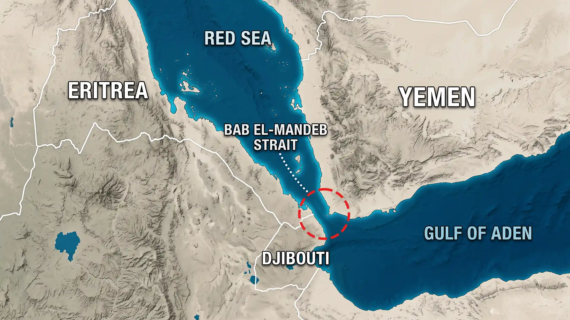
Bab el-Mandeb connects the Red Sea with the Gulf of Aden.
The Gulf of Aden opens into the Arabian Sea and Indian Ocean.
Therefore, the strait forms the Red Sea’s southern maritime entrance.
Location in simple map terms
- Yemen lies on the eastern, Arabian Peninsula side, and Djibouti lies on the western, Horn of Africa side.
- Eritrea borders the wider northwestern approach, and the Red Sea lies to the north.
- The Gulf of Aden lies to the southeast.
What does the name mean?
The Arabic name is commonly translated as “Gate of Tears”, although its exact historical origin is uncertain.
Explanations connect it with dangerous navigation or an ancient legend.
Therefore, one story should not be presented as proven etymology.
How narrow is the passage?
Measurements vary with the selected headlands and channel boundaries.
Sources commonly place the narrow crossing between 26 and 32 kilometres.
Perim, also called Mayyun, divides it into two channels.
| Channel | Location | Character |
|---|---|---|
| Bab Iskender | Between Perim and Yemen | Narrower and shallower eastern passage |
| Dact-el-Mayun | Between Perim and Africa | Wider and deeper western passage |
Large international vessels mainly use the deeper western passage, while the Seven Brothers lie nearer Africa.
Why is it called a chokepoint?
A maritime chokepoint concentrates shipping through a narrow route.
Bab el-Mandeb sits on the shortest sea route between Asia and Europe.
Northbound ships continue through the Red Sea and Suez Canal.
Southbound ships enter the Gulf of Aden and Indian Ocean.
A serious disruption can force ships around Africa’s Cape of Good Hope.
That diversion adds time, fuel, insurance costs and vessel demand.
How its importance grew
| Period | Importance |
|---|---|
| Ancient period | Traders linked the Red Sea with Arabia, Africa and India. |
| 1869 | The Suez Canal created a much shorter Europe-Asia sea route. |
| Twentieth century | Oil tankers made the passage central to energy security. |
| Late 2023 onward | Houthi attacks caused major commercial shipping diversions. |
| July 2026 | A new Houthi warning targeted trade connected with Saudi ports. |
What exactly was the latest threat?
The Houthi announcement warned shipping companies and threatened vessels serving Saudi ports.
This was a declared targeting policy, not complete closure, and Saudi authorities rejected its underlying allegation.
They also stated that coalition forces would protect commercial shipping.
What happened to energy flows?
Security risks had already reduced petroleum transit from recent peaks.
United States energy data estimated 9.3 million barrels daily during 2023.
The estimate fell to 4.1 million barrels daily during 2024.
It remained near 4.2 million during the first half of 2025.
Liquefied natural gas transit became negligible during 2024 and early 2025.
These figures measure flows, not the strait’s maximum physical capacity.
Why does India care?
- India’s trade with Europe commonly uses the Suez route, and long diversions raise freight and insurance costs.
- Container delays affect exporters and importers, and energy prices can respond to wider shipping uncertainty.
- Indian sailors work aboard many international commercial vessels.
Nearby strategic locations
- The Suez Canal lies far north beyond the Red Sea, and Djibouti hosts military facilities belonging to several countries.
- Yemen’s western coast overlooks important shipping approaches, and the Gulf of Aden leads towards the Arabian Sea.
Conclusion
Bab el-Mandeb’s narrow geography turns regional conflict into a global economic risk.