
Why in news?
India issued a maritime security advisory for the Black Sea on 23 July 2026. It covers Indian ships and foreign ships carrying Indian seafarers. Recent attacks had placed commercial crews at serious risk. One attack on motor vessel (MV) Golden Leo killed four Indian nationals.
Background
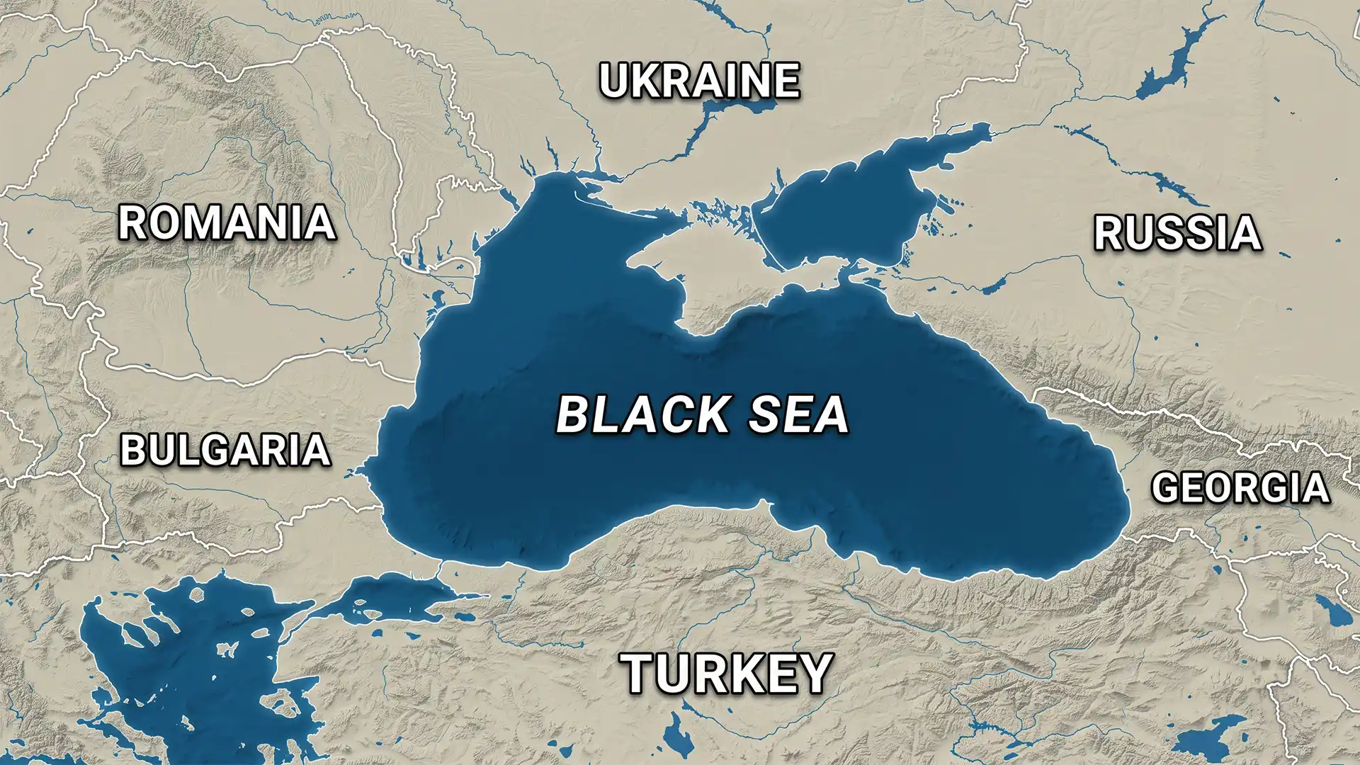
The Black Sea lies between south-eastern Europe and western Asia, with indirect connections to the Atlantic Ocean.
Its surface covers roughly 436,000 square kilometres, while the Crimean Peninsula projects deeply into its northern part.
Six countries border the Black Sea: Bulgaria, Romania, Ukraine, Russia, Georgia and Türkiye.
Countries around the sea
| Relative side | Coastal countries |
|---|---|
| North | Ukraine lies along much of the northern coast. |
| North-east | Russia lies along the north-eastern coast. |
| East | Georgia occupies the eastern coastal section. |
| South | Türkiye forms the long southern coastal section. |
| West | Bulgaria and Romania occupy the western coast. |
How does it connect with other seas?
- The Bosporus Strait links the Black Sea with the Sea of Marmara.
- The Dardanelles Strait links the Sea of Marmara with the Aegean Sea.
- The Aegean Sea opens into the wider Mediterranean Sea.
- The Mediterranean reaches the Atlantic through the Strait of Gibraltar.
The Bosporus, Marmara and Dardanelles form the Turkish Straits, with Türkiye controlling both sides of these strategic waterways.
In the north-east, the Kerch Strait links the Black Sea with the Sea of Azov.
Major rivers entering the Black Sea
- The Danube enters through a large delta shared by Romania and Ukraine.
- The Dniester reaches the north-western part of the sea.
- The Dnieper drains a large part of eastern Europe.
- The Southern Bug also enters the north-western coastal region.
- The Rioni carries water from Georgia into the eastern sea.
Why is its salinity relatively low?
Large rivers bring freshwater into the basin, while narrow straits restrict exchange with the saltier Mediterranean.
Fresh surface water remains above denser, saltier deep water, creating layers called stratification.
Weak vertical mixing limits oxygen below, leaving much of the deep basin anoxic, or oxygen-free.
Hydrogen sulphide occurs in deep water, while most larger organisms survive within the oxygenated upper layer.
The Black Sea is the world’s largest natural anoxic basin. More than 90 per cent of its water volume lacks oxygen.
Coastline and island facts
- Russia is commonly listed as having the longest Black Sea coastline.
- Coastline totals vary because methods differ and Crimea remains internationally disputed.
- Dzharylhach, off Ukraine, is generally described as the sea’s largest island.
- Ukraine has several islands and long lagoon-backed coastal sections.
The Montreux Convention
The 1936 Montreux Convention Regarding the Regime of the Straits governs passage through the Turkish Straits.
Merchant ships generally enjoy conditional passage, but special rules apply during war or an immediate threat to Türkiye.
The Convention limits non-Black Sea warships by type, tonnage and duration while giving coastal countries wider naval rights.
Why is the Black Sea economically important?
- Its ports handle grain, fertiliser, petroleum products and manufactured goods.
- The Danube provides an inland transport link towards Central Europe.
- Energy pipelines and cables cross or approach the wider basin.
- Coastal tourism, fisheries and shipbuilding support regional economies.
- Its straits provide the only maritime exit for Black Sea countries.
What prompted India’s advisory?
During the continuing conflict, increasing missile and drone attacks created risks beyond military ships.
MV Golden Leo carried five Indian crew members when attacked while departing Odesa port.
Four Indian nationals died and another suffered critical injuries, prompting India to condemn attacks against civilian shipping.
The Directorate General of Shipping then issued Circular 41 of 2026, advising maximum caution and voyage-specific security assessments.
What should a voyage assessment examine?
- Operators should review the planned route and all intended ports.
- They should check current navigational and security warnings.
- They should examine shelter, communications and emergency procedures.
- They should maintain contact with maritime and consular authorities.
- Seafarers should understand insurance and evacuation arrangements before sailing.
Conclusion
The Black Sea connects vital trade with active conflict, making geography central to its security and economic importance.