
Why in news?
A magnitude 7.3 earthquake struck offshore southern Mexico on 17 July 2026. Its Chiapas coast location prompted precautionary tsunami messages for nearby shores. Early assessments found no deaths or widespread structural damage.
Background
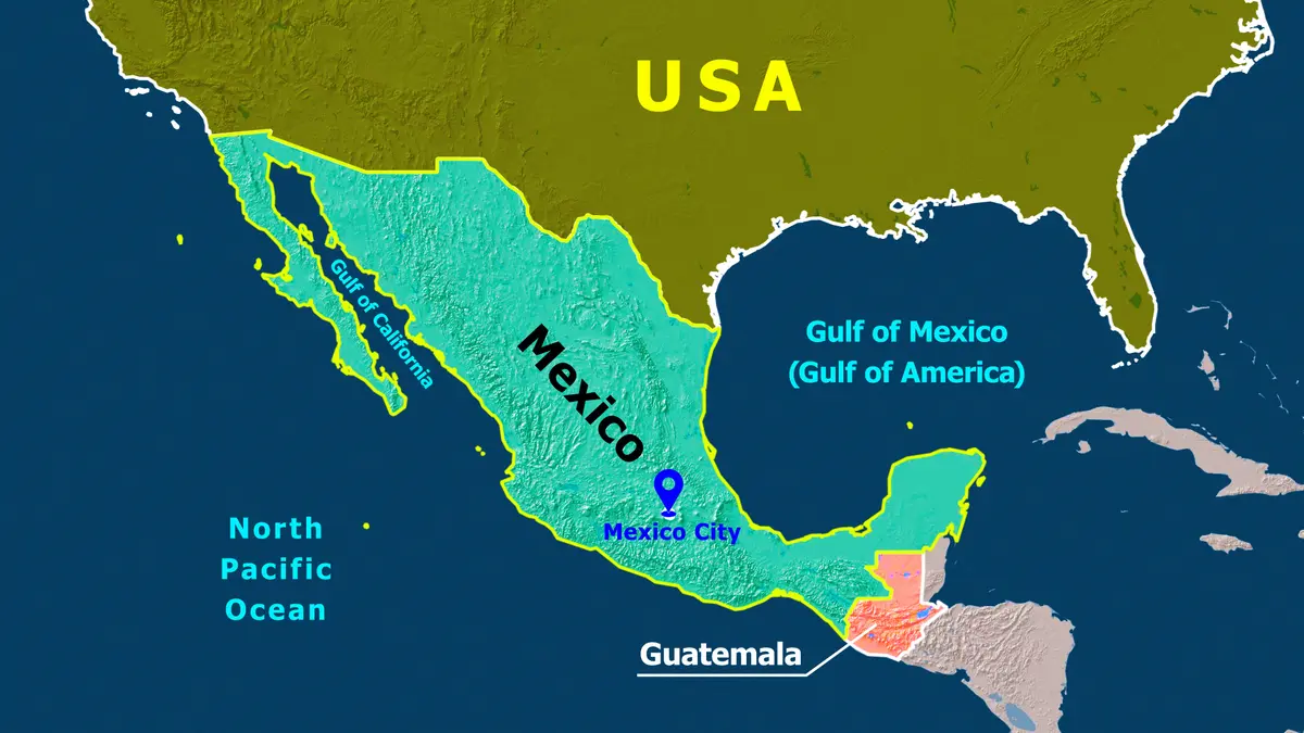
Mexico occupies southern North America, with the United States along its northern border.
Guatemala and Belize lie southeast, while the Pacific Ocean borders Mexico westward and southward.
The Gulf of Mexico lies eastward, and the Caribbean Sea touches the southeastern coast.
Mexico City is the capital of a federal republic containing 31 states.
Spanish is the dominant language, alongside many recognised Indigenous languages.
What happened during the earthquake?
The earthquake occurred near Mexico’s southern Pacific coast.
The final magnitude was 7.3, replacing an initial automatic estimate of 7.4.
Its focus was about 15 kilometres deep, with the epicentre roughly 58 kilometres from Puerto Madero.
Southern Mexico and neighbouring Guatemala felt strong shaking, followed by several aftershocks.
Authorities warned coasts within about 300 kilometres of possible waves.
The warning was later lifted, while later reports mentioned injuries but no deaths or major destruction.
Reading breaking news: Early magnitude figures often change after scientists analyse more seismic data. The revised 7.3 value is therefore preferable to the first estimate.
Why is Mexico highly earthquake-prone?
Mexico lies where several large tectonic plates interact.
They include the North American, Pacific and Cocos plates, while the smaller Rivera plate affects western Mexico.
Along the southern coast, Cocos plate subduction carries oceanic crust beneath continental Mexico.
Along the Middle America Trench, locked plates build stress before sudden slipping releases seismic energy.
This mechanism places Mexico within the Pacific Ring of Fire’s earthquake and volcanic belt.
Are all Mexican plate boundaries alike?
The Cocos plate moves northeastward, forcing dense oceanic crust beneath lighter continental crust.
Subduction also melts mantle material, helping feed volcanoes across the Trans-Mexican Volcanic Belt.
The Gulf of California instead marks separation and sideways movement between Pacific and North American plates.
Mexico therefore contains several boundary types rather than one identical earthquake mechanism everywhere.
What do common earthquake terms mean?
| Term | Simple meaning |
|---|---|
| Focus or hypocentre | The underground point where rupture begins. |
| Epicentre | The surface point directly above the focus. |
| Magnitude | A measure of energy released by the earthquake. |
| Intensity | The observed shaking and damage at a particular place. |
| Aftershock | A later earthquake near the first rupture area. |
| Subduction | One tectonic plate sinks beneath another plate. |
Shallow earthquakes often create stronger nearby shaking, but damage also depends on buildings, ground and distance.
Mexico City’s soft lake sediments amplified shaking severely during the destructive 1985 earthquake.
Why was a tsunami warning issued?
A large undersea earthquake can move the seabed and displace a huge seawater column.
The resulting long waves travel outward, then slow and grow taller within shallow coastal water.
Not every offshore earthquake creates a tsunami; fault movement, depth and seabed displacement determine danger.
Because coastal evacuation needs time, a warning signals possible danger rather than confirmed devastation.
What are Mexico’s major physical features?
- The Baja California Peninsula extends along the northwestern Pacific side.
- The Yucatán Peninsula projects between the Gulf and Caribbean Sea.
- The Mexican Plateau occupies much of the country’s interior.
- The Sierra Madre Occidental and Oriental border opposite sides of the interior.
- The Trans-Mexican Volcanic Belt crosses heavily populated central Mexico.
- The Rio Grande forms much of the United States boundary.
Chiapas adjoins Guatemala and the Pacific, explaining why Guatemala also felt this earthquake.
Map point: Mexico separates the Pacific Ocean from the Gulf of Mexico. The Isthmus of Tehuantepec forms the country’s narrowest mainland section.
How can countries reduce earthquake losses?
- Hazard-based building codes should also strengthen older schools and hospitals.
- Early-warning systems can provide seconds for protective action before shaking.
- Coastal maps and public drills should explain tsunami evacuation routes.
- Emergency communication must continue during widespread electricity and network failures.
Alerts can arrive first because electronic signals travel faster than destructive seismic waves.
Exact prediction remains impossible, so preparedness reduces exposure and vulnerability before earthquakes occur.
Conclusion
Mexico’s earthquake risk comes directly from its position above active plate boundaries.