

Why in news?
An earthquake struck near Suez early on 3 August 2026. The United States Geological Survey measured magnitude 5.0. Egyptian reporting used somewhat higher preliminary magnitudes. No immediate major damage or casualties were reported.
Background
The earthquake occurred at 00:00 Coordinated Universal Time; that was about 3:00 am under Egypt's daylight-saving time. The United States Geological Survey located it 36 kilometres north-northeast of Suez.
Its reviewed coordinates were 30.2922 degrees north and 32.6273 degrees east. The depth was ten kilometres; shallow earthquakes can produce noticeable surface shaking even at moderate magnitudes.
Egyptian monitoring and early media reports gave values around 5.4 or 5.6. Such differences commonly arise during rapid analysis. Agencies may use different station networks, models and magnitude scales.
Magnitude, intensity and depth
Magnitude estimates the energy released at the earthquake source. Each whole-number increase represents a large rise in measured ground motion and energy. Modern agencies commonly report moment magnitude for moderate and large events.
Intensity instead describes observed shaking and damage at a particular place. It changes with distance, soil, building quality and local geology. One earthquake can therefore produce several intensity levels.
Depth influences effects; a shallow event usually feels stronger nearby than a deeper event of equal magnitude. Distance from population centres and construction quality then shape actual losses.
Why earthquakes occur around Suez
Suez stands near the northern Gulf of Suez and the Red Sea rift system. This region records crustal stretching linked with separation between Africa and Arabia. Faults created by that tectonic history can still produce earthquakes.
The Gulf of Aqaba further east marks another active plate boundary zone. Seismic risk therefore varies considerably across Egypt. The Nile Valley interior is generally less active than the country's eastern rift margins.
Local sediments can amplify shaking around cities and infrastructure. The Suez Canal corridor also carries dense industrial and transport assets. Moderate events therefore justify inspection even when visible damage appears limited.
Egypt's geographical setting
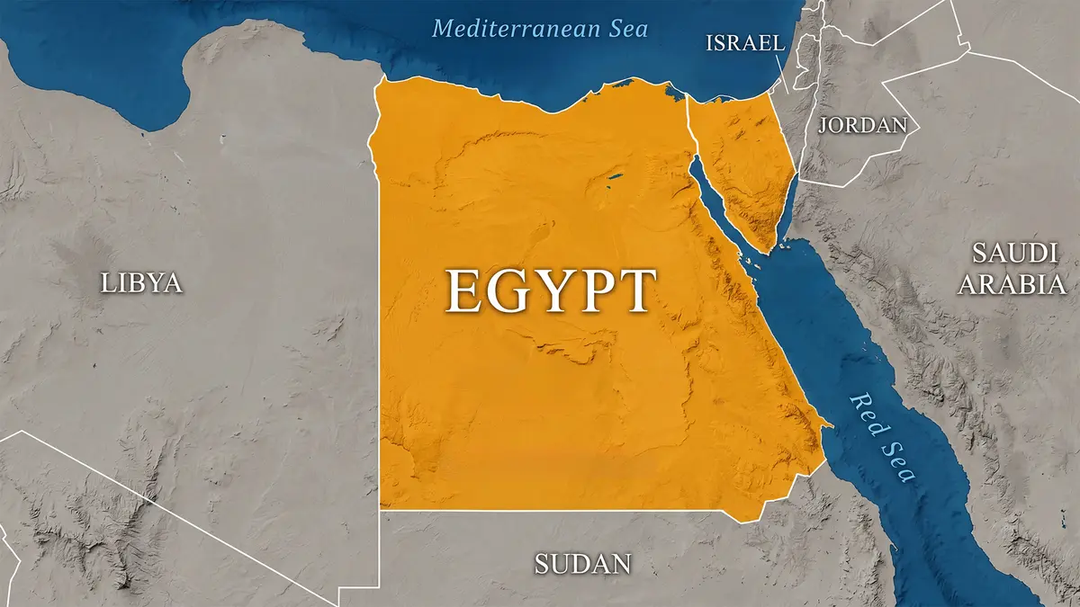
Most of Egypt lies in Africa; the Sinai Peninsula extends into Asia, making Egypt transcontinental. Libya borders it westward, while Sudan lies to the south.
Egypt borders Israel and the Gaza Strip; the Mediterranean Sea forms its northern coast. The Red Sea and its gulfs lie along the east.
The Suez Canal crosses the Isthmus of Suez. It connects the Mediterranean Sea with the Red Sea without locks. This route greatly shortens maritime journeys between Europe and the Indian Ocean.
The Nile sustains most settlement and agriculture within an overwhelmingly arid country. Calling it unquestionably the world's longest river is unsafe because measurement methods create a continuing Amazon comparison.
Risk reduction
Earthquake preparedness depends mainly upon safer buildings and infrastructure. Monitoring can rapidly locate an event but cannot reliably predict its exact time. Emergency drills, inspections and public information reduce secondary losses.
Critical facilities around the canal need continuity plans for transport disruption. Authorities should also examine pipelines, ports and industrial storage after significant shaking. Transparent post-event reporting helps distinguish verified damage from social-media rumours.
Why source attribution matters after earthquakes
Automatic systems publish preliminary locations, while analysts later add stations and refine models. Revised catalogues may shift epicentres or magnitudes, so reports should preserve agencies and update times.
The hypocentre marks where rupture begins underground, while the epicentre lies directly above it on Earth's surface. Neither term describes the entire fault area that slipped during the earthquake.
Moderate shaking can damage vulnerable buildings, making rapid inspections more useful than judging impact from magnitude alone. Engineers should prioritise schools, hospitals and older masonry because aftershocks may weaken damaged structures.
Egypt's network provides local readings, while international catalogues offer comparison and standard processing. Differences require technical reconciliation, and final catalogues provide the soundest basis for long-term hazard studies.
Conclusion
The Suez earthquake was moderate and initially caused no reported major losses. Its differing magnitude estimates show why early seismic figures require careful attribution.