

Why in news?
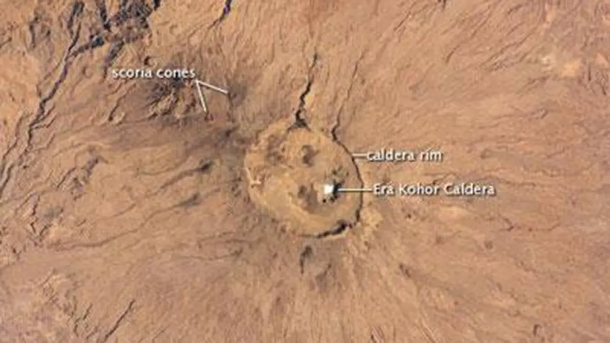
A science feature published on 22 September has renewed attention to an astronaut photograph of Emi Koussi in northern Chad. The broad volcano rises above the Sahara, but its striking white summit patch is salt rather than snow. The image was taken on 29 December 2024 and published by the National Aeronautics and Space Administration in May 2025. It shows a dry lake bed inside the mountain's volcanic depressions. The feature is therefore an explanation of an existing image, not an announcement of a new eruption. Its interest lies in how volcanic activity, occasional flowing water and evaporation have shaped the same desert landscape.
Locating the mountain
Emi Koussi stands at the southeastern end of the Tibesti mountain region. The Tibesti extends across northern Chad and southern Libya, within the central Sahara. Emi Koussi itself is in Chad. Its summit reaches 3,415 metres above sea level, which the space agency identifies as the Sahara's highest point. That is a regional comparison, not a claim that it is Africa's highest mountain or its tallest volcano.
The mountain is much broader than the narrow cone often associated with volcanoes. Its lava-built mass extends for many tens of kilometres. The Smithsonian's Global Volcanism Program describes a massif roughly 60 by 80 kilometres across. These dimensions refer to the broad volcanic structure, not the opening at its summit. Distinguishing the whole mountain from its nested depressions prevents different measurements from being combined into a misleading description.
A shield built up, then cut by depressions
A shield volcano develops through repeated eruptions that spread lava over a broad area. Its overall profile can therefore be wide and gently sloping, even when the mountain is very high. Emi Koussi also contains deposits and vents associated with explosive activity. A volcano's broad classification does not imply that every eruption followed one simple pattern. Different eruptions can leave overlapping flows, cones and depressions during a long history.
At the summit, large nested calderas form an elongated depression. A caldera develops when the ground subsides after magma withdrawal removes support beneath it, often during major eruptions. This differs from treating every circular hollow as the mouth of a single explosion. The Smithsonian describes the combined summit depression as approximately 12 by 15 kilometres. The highest point lies on its rim, so the floor is substantially below the mountain's summit elevation.
Within the southeastern part of that larger depression lies Era Kohor, a smaller crater roughly two to three kilometres wide. The volcano's later features include explosion craters, cinder cones and lava flows. A maar is a crater excavated by explosive interaction involving magma and water. A cinder cone, by contrast, is built from erupted fragments accumulating around a vent. Such distinctions explain why circular landforms can have different origins despite their similar appearance from space.
Why salt collects inside the summit
The astronaut photograph shows a white deposit on the bed of a small dry lake. The space agency places it about 745 metres below the summit, at a low point within the volcanic depression. This vertical difference is not the depth of every crater on the mountain. It compares the salt bed with the summit. Shadows and the bright deposit make the surrounding relief especially clear in the image.
Water can dissolve minerals as it passes over and through rocks. Where it accumulates in a closed depression, evaporation removes water while leaving dissolved material behind. Repeated wetting and drying can concentrate salts on the floor. A bright surface therefore need not indicate ice, especially in an arid basin. The visible deposit connects the mountain's enclosed topography with the movement and eventual loss of water.
Dry channels also radiate down the volcano's slopes. They show that running water has eroded the landscape even though present rainfall is very low. Concentrated runoff can cut channels over long periods, particularly where slopes direct water into the same routes. The space agency identifies deep canyons between Emi Koussi and neighbouring Tarso Ahon. Their presence makes clear that a desert is not a landscape untouched by water.
What can be said about volcanic activity?
The Smithsonian database does not give a securely established date for Emi Koussi's last eruption. It reports no known Holocene eruptions, referring to the geological interval covering roughly the last 11,700 years. The database also records a thermal area on the volcano's southern flank. These facts do not support announcing an imminent eruption. Equally, the absence of a dated recent eruption is not the same as proving that a volcano can never erupt again.
The photograph is an observation of surface form, not a direct measurement of underground magma. Lava flows and craters preserve earlier activity, but their ages need geological investigation. Temperature, gas and seismic observations answer other questions about a volcanic system. Calling the mountain simply “extinct” would hide the uncertainty recorded by the specialist database. The more useful account explains what the landforms reveal and where the eruption chronology remains incomplete.
Conclusion
Emi Koussi brings several physical processes into one view: broad volcanic construction, summit subsidence, later vents and water-driven erosion. Its white salt bed records evaporation within a depression rather than a snow-covered peak. Understanding the scale of each feature makes the photograph more informative than a striking colour contrast alone. It also preserves the distinction between visible evidence of past volcanism and an established assessment of future activity.