

Why in news?
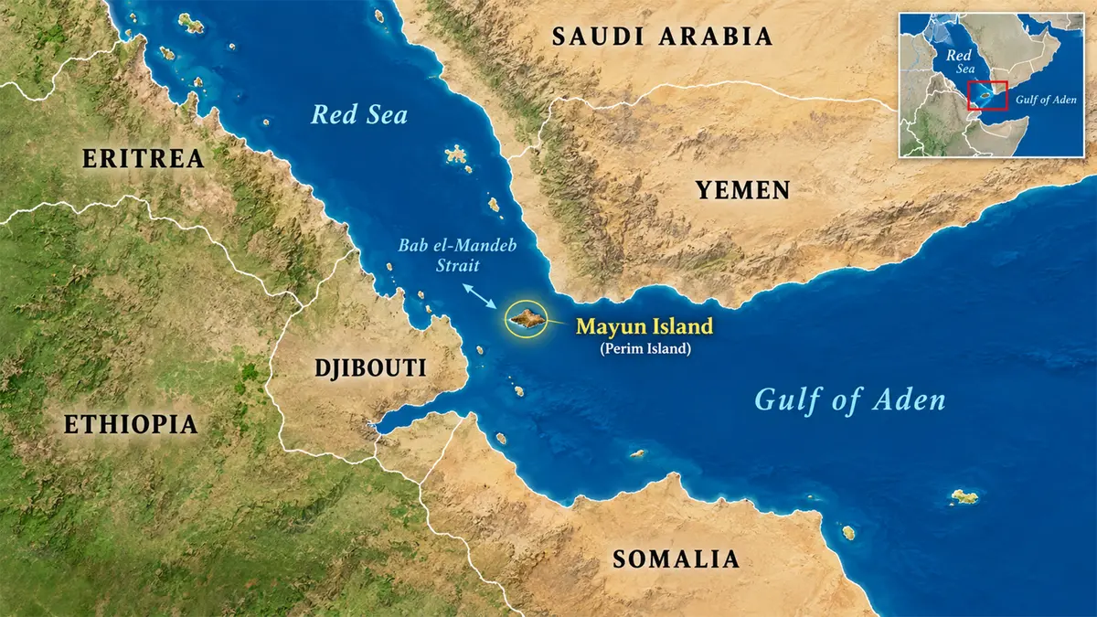
Yemen’s Houthi movement captured Mayun Island, according to Associated Press reporting published on 11–12 September 2026. The account cited a Yemeni government military official and a Houthi official. Also known as Perim, the island lies in the Bab-el-Mandeb Strait, which connects the Red Sea with the Gulf of Aden. Ships using the Suez route between the Mediterranean and Indian Ocean pass through this narrow gateway. Control of land beside it can therefore increase concern about surveillance, attacks and the security of commercial voyages. The development matters especially because earlier attacks had already diverted substantial traffic away from the Red Sea. The reported capture changes the military situation on the island; it does not by itself establish that the strait is closed to shipping.
Locating the island and the strait
Mayun belongs to Yemen and sits near the southern entrance to the Red Sea. Yemen occupies the south-western part of the Arabian Peninsula. Its land neighbours are Saudi Arabia to the north and Oman to the north-east. Its coasts face the Red Sea, Gulf of Aden and Arabian Sea.
Across Bab-el-Mandeb lies the African side of the gateway, associated with Djibouti and Eritrea. The strait separates the Arabian Peninsula from the Horn of Africa. The Gulf of Aden opens eastwards towards the Arabian Sea and Indian Ocean. Northwards, the Red Sea leads towards Egypt and the Suez Canal.
This sequence makes the geography easier to understand: Indian Ocean, Gulf of Aden, Bab-el-Mandeb, Red Sea, then Suez and the Mediterranean. Mayun is positioned at the southern sea passage, not inside the Suez Canal. Trouble at either end can affect a voyage using the complete route, even though the two places are far apart.
Why a small island can have strategic weight
A maritime chokepoint is a constrained passage through which important shipping routes converge. Its significance depends on the traffic using it and the availability of alternatives. A relatively small area can consequently influence voyages linking distant ports. Mayun’s importance comes from this position, rather than from a large land area or population.
An island near a shipping lane can provide a location for observation and military activity. However, geographical proximity alone does not demonstrate a particular weapon’s range or the ability to stop every vessel. Assessing those capabilities requires information about equipment, deployment and naval responses. The capture report should not be expanded into unsupported claims of complete sea control.
The Houthis, also known as Ansar Allah, are an armed political movement originating in northern Yemen. They are a party to the country’s conflict, not another country bordering the strait. The Australian government’s country brief traces their emergence and confrontation with the central authorities. Their territorial control must be distinguished from Yemen’s international boundaries.
What the capture report establishes
Associated Press reported the island’s capture using officials from opposing sides, while withholding their names because they lacked authorisation to speak publicly. That is a specific reporting basis, not a detailed independent account of the operation. The same coverage described Houthi statements about threats to Saudi shipping. Such statements are claims by a conflict participant, not guarantees for other vessels.
The practical questions extend beyond the announcement: which forces remain on the island, what systems they deploy and how shipping responds. Those answers can change during a conflict. A reported change in control is therefore one development within an evolving security situation. It should not be confused with a lasting settlement of the island’s political status.
What earlier shipping changes reveal
The United States Energy Information Administration provides a useful measure of the route’s recent disruption. It estimated oil flows through Bab-el-Mandeb at 9.3 million barrels daily in 2023. The figure fell to 4.1 million in 2024 and remained around 4.2 million during the first half of 2025.
These figures cover petroleum flows, including crude oil and petroleum products; they are not a count of all world trade. They also describe periods before the September 2026 island report. Their relevance is to show that security concerns had already changed route use. They do not measure an economic effect caused by this latest capture.
Ships avoiding the Red Sea can sail around Africa’s Cape of Good Hope instead. The detour avoids Bab-el-Mandeb and Suez but lengthens many Asia–Europe journeys. Additional sailing time affects fuel use, vessel availability and delivery schedules. The size of the effect depends on the ports, cargo and route involved; it is not identical for every shipment.
Conclusion
Mayun’s location explains why an island capture can have consequences far beyond Yemen. It lies beside a gateway connecting two major maritime regions and a route already affected by insecurity. The immediate development is the reported change in military control. Its wider impact will depend on actual deployments, attacks and shipping decisions, rather than the announcement alone.