

Why in news?
North Korea reportedly fired two ballistic missiles towards the Sea of Japan on 20 September 2026. Japan's Prime Minister's Office issued instructions that day to collect information, protect aircraft and vessels, and prepare for contingencies. The sea lies between the Asian mainland and the Japanese archipelago, making it a shared regional space rather than an isolated launch area. Its coastlines and narrow connections to neighbouring waters help explain why such incidents attract attention across several countries. The immediate announcement establishes an official safety response. It does not, by itself, identify the missiles' precise characteristics or establish their exact landing positions.
A sea bounded by four countries
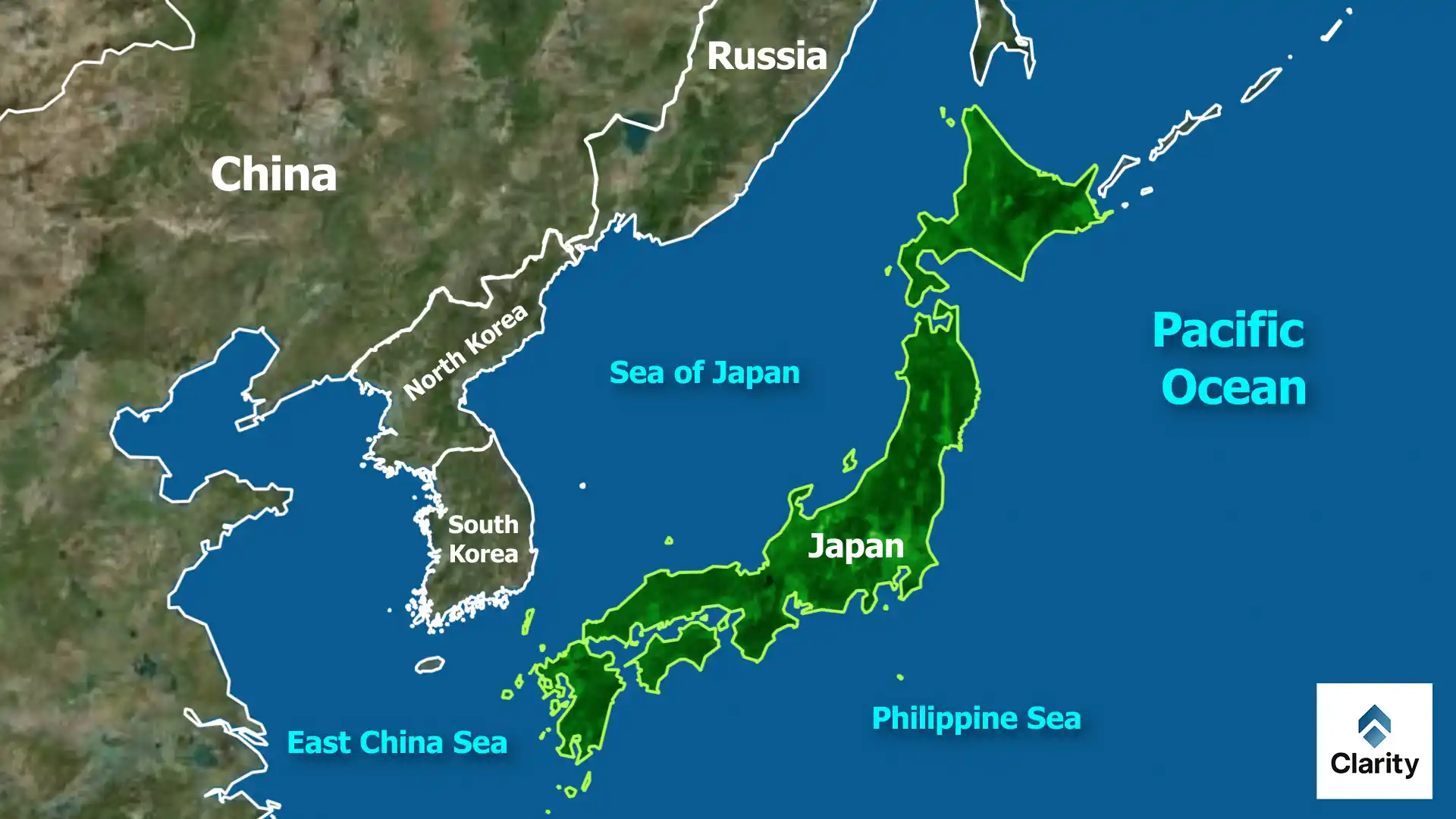
The Sea of Japan is a marginal sea of the north-western Pacific. Japan forms its eastern side, while Russia and the Korean Peninsula form much of its northern and western rim. Its coastal countries are Japan, Russia, North Korea and South Korea. Hokkaido, Honshu and the northern approaches around Kyushu help define the Japanese side. Sakhalin is important to the north. These physical boundaries explain why reports from different governments may describe the same maritime incident from different directions.
The water body is also called the East Sea in Korean usage. Recognising that naming difference helps readers compare reports without mistaking the terms for separate seas. Neither name alone establishes sovereignty over the entire water body. When following a security story, the relevant questions concern the actual route, location and affected users. A general reference to the sea is less precise than a confirmed position and should not be treated as equivalent evidence.
The straits connect it to the wider ocean
In the south, the Korea Strait, including the Tsushima passages, connects the sea with the East China Sea. To the east, Tsugaru Strait lies between Honshu and Hokkaido and opens towards the Pacific. Farther north, Soya Strait, also called La Pérouse Strait, separates Hokkaido from Sakhalin and connects with the Sea of Okhotsk. The Tatar or Tartary Strait runs between Sakhalin and the Russian mainland, forming the sea's northern connection towards the Okhotsk system.
These passages are much shallower than the sea's interior basins. That contrast has an important consequence: surface waters can move through the openings more readily than deep waters. The sea is therefore connected to the ocean but partly enclosed in its circulation. It is not a landlocked lake, and it is not simply an unrestricted extension of the deep Pacific. The shape and depth of the entrances help determine how water, heat and dissolved substances move through it.
A deep interior divided into basins
The seabed includes the Japan Basin in the north, the Yamato Basin towards the south-east, and the Ulleung or Tsushima Basin towards the south-west. The Yamato Rise separates parts of this deeper terrain. A basin is a depressed area of seabed; a rise or seamount is an elevated feature. These features divide the interior into connected compartments rather than one evenly shaped bowl. The contrast between deep basins and shallow connecting straits helps explain the sea's distinctive circulation.
Japanese oceanographic research uses this enclosed geometry to study circulation and environmental change. Water in the deep interior is not renewed in the same way as surface water passing through a strait. Researchers therefore distinguish the upper layer from deeper water masses when examining temperature, salinity and oxygen. A measurement from a warm surface current should not be casually applied to the whole sea, especially to its cold deep waters.
Warm inflow and a cold-season response
The Tsushima Warm Current brings water into the sea from the south. Some of that water leaves towards the Pacific through Tsugaru Strait. The Japan Agency for Marine-Earth Science and Technology studies this outflow and its interaction with colder waters east of northern Japan. The connection matters because a current carries heat and water properties, not merely motion. Changes near a strait can therefore affect conditions beyond the narrow passage itself.
Winter adds a different influence. Cold air moving from the Asian continent passes over the sea and gains heat and moisture. When that air reaches Japan's mountainous terrain, it helps produce heavy snowfall on the Sea of Japan side. The Japan Meteorological Agency contrasts this with the often sunnier Pacific side during the same winter pattern. The sea is thus part of a land–air–ocean relationship, not just a boundary between countries on a map.
Why the geography matters for the news
A missile report concerns a region used by civilian ships and aircraft as well as military forces. Japan's instructions explicitly included their safety, alongside information gathering and contingency preparation. That response should be reported separately from any later technical assessment. At the date of this edition, the cited instructions alone do not justify claims about damage, interception or a particular missile's performance. Keeping those distinctions clear prevents a short security announcement from becoming an invented account of events.
Conclusion
The Sea of Japan's significance comes from the relationship between its four coastal countries, narrow straits and deep interior. The same geography shapes circulation, snowfall and regional security concerns. Accurate coverage connects those features to the reported event while leaving unconfirmed launch details clearly unresolved.