

Why in news?
Researchers have modelled how water may once have escaped from lakes inside Valles Marineris on Mars. Their calculations suggest a major breach could have released about 1,245 trillion cubic metres. The model routes this water through eastern channels towards the northern lowlands. Its reported sea-level effect concerns a hypothetical ancient ocean, not a confirmed modern sea.
What the new work proposes
The research team was led by Sajin Kumar of the University of Kerala. Collaborators came from Indian and overseas institutions. They used two-dimensional hydraulic modelling to simulate water stored within the canyon system. The first detailed report appeared in The Hindu on 5 September.
The model estimated that ancient water bodies held about 2,369 trillion cubic metres. It then simulated the release of roughly half that quantity. A principal breach near Eos Chasma carried water into Aurorae Chaos. Smaller flows were modelled through Daga Vallis and Columbia Valles.
From there, water could cross Chryse Planitia and reach Mars's northern lowlands. Researchers calculated a transient local rise of about 324 metres near the flow terminus. Across a proposed northern ocean, the mean increase would be about 34 metres. Every figure depends upon assumed topography, storage and ocean extent.
Understanding Valles Marineris
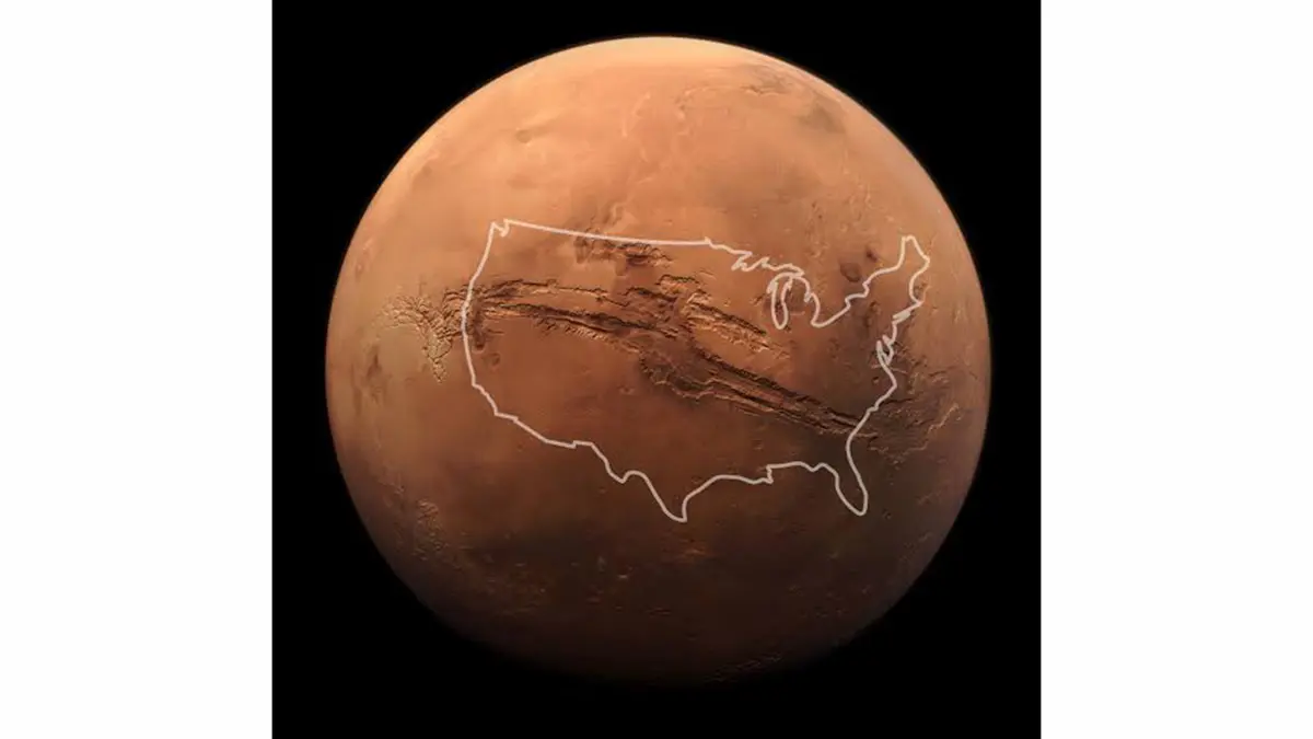
Valles Marineris is an immense connected canyon system just south of the Martian equator. NASA gives its length as about 3,870 kilometres. It reaches roughly 600 kilometres across and 9.3 kilometres deep. These dimensions make it the largest known canyon system in the Solar System.
The canyon extends eastward from the Tharsis volcanic rise. Much of it formed when the crust fractured and pulled apart during Tharsis uplift. Landslides later widened walls and filled parts of the floor. Wind, sediment and water altered the landscape after the initial faulting.
It was therefore not carved entirely by one giant river. Several interior basins nevertheless show evidence consistent with standing or flowing water. Eastern chaotic terrains connect the canyon with large outflow channels. This combined history makes the region suitable for flood modelling.
The proposed route to the north
Eos Chasma forms part of Valles Marineris's eastern end. Aurorae Chaos lies farther east, where blocks of collapsed terrain mark major disruption. Water leaving this area could enter broad channels towards Chryse Planitia. Chryse is a low plain opening towards the northern hemisphere.
Some researchers call the proposed northern water body Oceanus Borealis. Shoreline-like landforms and sedimentary evidence support versions of that idea. Their elevations and ages do not always agree. The existence, size and duration of any ocean remain active scientific questions.
The new estimate should be read within that uncertainty. A 34-metre rise describes a modelled average over a specified ocean area. It is not a measured shoreline change. Alternative boundaries or leakage assumptions would produce different results.
Earlier evidence for floods and lakes
United States Geological Survey research has identified possible lake deposits within central Valles Marineris. It described ponding, spillways and sediment linked with major floods. Other studies have examined channels connecting the canyon with the northern plains. These features establish a plausible physical setting for the new simulation.
Recent research has also reported fan-delta landforms at comparable elevations. Deltas form where flowing water loses energy and deposits sediment. Similar heights can indicate a connected standing-water level. They still require careful dating and geological interpretation.
Mars had a thicker atmosphere and more surface water early in its history. Its river valleys, deltas and lakebeds preserve that past. Later cooling and atmospheric loss made the surface far drier. Water now survives mainly as ice or bound within minerals.
Why hydraulic modelling is useful
A model turns mapped landforms into testable flow estimates. Researchers can ask whether proposed volumes fit channel size and topographic routes. They can compare water speed, depth and inundation against observed deposits. Poor agreement would weaken the proposed event.
Models also make assumptions visible. Starting water level, ground elevation and surface resistance influence the outcome. Martian terrain has changed since any ancient flood occurred. Results should therefore be presented with uncertainty ranges and alternative cases.
The study can help future missions select useful geological targets. Sediments near a former lake or flood path may preserve environmental evidence. Orbital instruments can test mineral composition and layered deposits. A landing mission would provide much stronger local confirmation.
What the result does not show
The simulation does not prove that the entire calculated volume was present. It also does not date the proposed breach by itself. No present liquid sea exists in Valles Marineris. The work reconstructs a possible episode from ancient terrain.
Large flood volume does not establish biological habitability. Scientists would also need suitable chemistry, energy and stable conditions. A violent short-lived flood may preserve different evidence from a long lake. Geological scale and biological potential are separate questions.
Conclusion
The new model gives a testable scale for a possible ancient Martian flood. Valles Marineris contains landforms that make such work scientifically reasonable. Its largest numbers remain estimates tied to a hypothetical northern ocean. Independent geological evidence must test the proposed routes and water levels. Careful qualification makes the study more informative, not less important.