

Why in news?
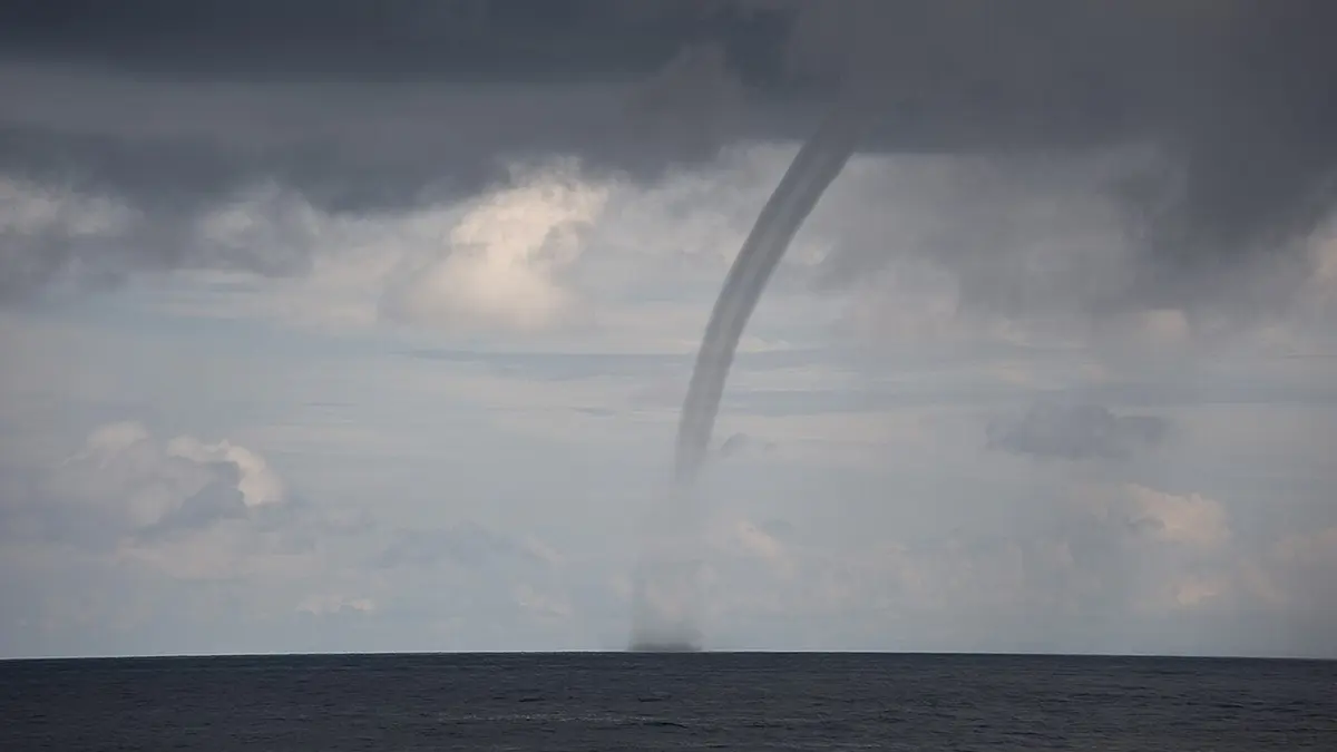
A rotating column appeared over the water at Ferry Reach in Bermuda on 22 August. A local resident filmed the small formation near the shore shortly before 11 a.m. Thunder, heavy cloud and a localised downpour affected Bermuda’s East End. The island’s daily newspaper reported the event as a modest waterspout on 24 August.
What a waterspout is
A waterspout is a rotating column of air over a water surface. Water mist and condensation make part of the circulation visible. The funnel does not consist of a solid column of lifted seawater. Spray is concentrated mainly near the surface.
The circulation must reach the water to qualify as a waterspout. A funnel cloud that remains above the surface is different. Observers should not approach either feature. A small vortex can strengthen or change direction.
Two broad types
Meteorologists distinguish fair-weather and tornadic waterspouts. A tornadic waterspout forms within a rotating severe thunderstorm. It may develop over water or move there from land. It can bring destructive wind, hail, lightning and high waves.
A fair-weather waterspout usually forms beneath developing cumulus clouds. Rotation begins near the water and grows upward. Light winds and warm water often support development. These waterspouts are usually smaller and shorter lived.
“Fair-weather” does not mean completely clear or harmless weather. Showers and developing clouds may be nearby. Some fair-weather waterspouts can still damage small boats. They usually weaken quickly after reaching land.
How a fair-weather waterspout develops
Warm, moist air rises from the water surface. Local boundaries can bring air together and create weak rotation. A growing cloud stretches the rotating column vertically. Stretching can increase its speed, much like a skater drawing in both arms.
The first visible sign may be a dark spot on the water. Spiral bands and a ring of spray can follow. A condensation funnel then connects the surface circulation with the cloud base. The structure fades when its warm inflow weakens.
The Bermuda event
The reported vortex lasted several minutes near Ferry Reach in St George’s. Thunder was developing north of the islands. A cloudburst soaked some areas while leaving much of the South Shore dry. Such sharp variation is typical of a small convective system.
The account called the event a modest example of microscale weather. That term refers to phenomena covering a small area and short time. Available reporting does not provide a formal wind rating. This edition therefore does not assign one.
Where Bermuda lies
Bermuda is a British Overseas Territory in the North Atlantic Ocean. It consists of many small islands joined partly by bridges and causeways. Cape Hatteras in North Carolina is the nearest mainland, about 1,030 kilometres away. Bermuda is not in the Caribbean Sea.
Ferry Reach lies in the East End near St George’s and the airport area. Narrow channels and sheltered water meet the open Atlantic nearby. The whole territory is exposed to marine weather. Warm ocean water can support strong summer convection.
Why small-scale events are difficult to forecast
A fair-weather waterspout can form between normal observation points. Its circulation may be too small for weather radar to resolve clearly. Conditions can become suitable within minutes. Reports from trained observers and boaters therefore remain useful.
Forecasts can identify a favourable environment rather than the exact funnel location. Meteorologists examine water temperature, humidity, instability and wind profiles. A line of dark, flat cloud bases can provide a visual warning. Thunderstorms increase the need for caution.
Safety on water and land
Boats should move away at a right angle to the apparent path. People should never approach for a better photograph. Marine warnings and local weather updates deserve attention. Small craft are especially vulnerable to wind and waves.
A waterspout moving ashore can damage structures and injure people. Shelter should follow local tornado or severe-weather advice. Lightning may remain dangerous after the funnel disappears. Drivers near shore should also avoid stopping in unsafe places.
Not every waterspout is a tornado from a severe storm
Tornadic and fair-weather waterspouts form through different processes. Both are rotating air columns over water. The surrounding storm and observed behaviour determine the correct description.
Conclusion
The Ferry Reach event was brief, local and visually striking. It offers a clear example of weather at the microscale. Correct classification matters because waterspouts range greatly in strength. Official warnings and distance remain the safest response. The event also shows why island communities need close observation of rapidly developing marine weather.