

Why in news?
A bus left a mountain road on Cape Verde’s Fogo Island on 5 September 2026. The crash killed 25 people and injured 14 others, according to officials. Many passengers were young people returning from an activity in the island’s highlands. Authorities declared two days of national mourning while investigators examined the cause.
What is confirmed about the crash?
The official resolution identified the route between Chã das Caldeiras and Campanas de Cima. News agencies reported 25 deaths and 14 injured passengers. Emergency teams moved survivors for medical care. The government expressed national solidarity with victims and their families.
Initial news reports described the bus falling down a steep slope. Exact distances and mechanical explanations were not established publicly. Road, vehicle and driver evidence require formal examination. Weather and witness accounts may also become relevant.
National mourning honours the dead but does not replace accountability. Investigators need access to the vehicle and journey records. Findings should distinguish immediate causes from deeper safety failures. Transparent results can guide prevention across the islands.
Understanding Cape Verde
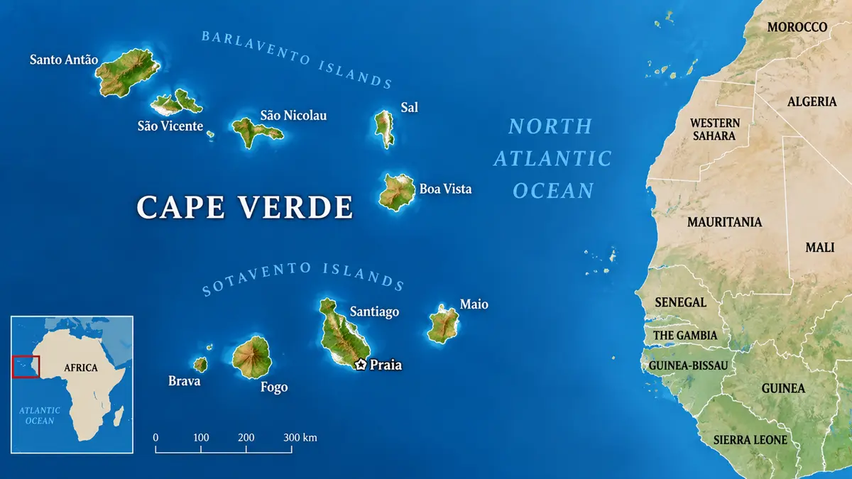
The country’s official Portuguese name is Cabo Verde. It is an Atlantic archipelago off the coast of West Africa. The islands lie about 455 kilometres west of the African mainland. Praia, on Santiago Island, is the capital and largest urban centre.
The state covers roughly 4,033 square kilometres across ten main volcanic islands. Nine islands are inhabited. They are grouped into northern Barlavento and southern Sotavento chains. Fogo belongs to the southern group with Santiago, Maio and Brava.
The archipelago rose through volcanic activity above an oceanic hotspot. Rainfall is low and highly variable. Steep terrain limits farmland and road construction on several islands. The Atlantic also separates communities and complicates emergency logistics.
Fogo’s physical setting
Fogo is dominated by a large active stratovolcano. A broad caldera surrounds the younger cone called Pico do Fogo. The summit reaches about 2,829 metres above sea level. It is the highest point in Cape Verde.
Chã das Caldeiras is a settlement and farming area inside the volcanic caldera. Roads climb sharply from coastal settlements into this highland basin. Slopes, bends and changing visibility make journeys demanding. Volcanic rock also shapes drainage and road foundations.
Pico do Fogo last erupted from November 2014 into early 2015. Lava destroyed homes and infrastructure within the caldera. That eruption is separate from the present road crash. It nevertheless explains the island’s dramatic landscape and settlement pattern.
Why island transport needs special planning
Mountain roads must balance access with limited stable ground. Protective barriers, drainage and slope inspection need regular maintenance. Heavy passenger loads increase the consequences of one failure. Vehicle checks are especially important where replacement fleets are limited.
Emergency response also faces geographic constraints. Specialist hospitals and equipment may be on another island. Aircraft and ferries depend upon weather and schedules. Local first responders therefore need strong rescue and trauma capacity.
Road-safety policy should rely upon verified crash data. Authorities can map dangerous bends, surface failures and recurring incidents. Driver training and enforceable vehicle standards must support engineering. Public education alone cannot correct unsafe infrastructure.
Economic and social context
Fogo’s highlands support vineyards, coffee and distinctive tourism. Visitors travel to the caldera for hiking and volcanic scenery. Reliable roads connect these activities with coastal towns. Safety failures can therefore affect households and the island economy together.
Cape Verde has built strong national institutions despite scarce land and water. Its islands still face uneven access to specialised services. A major disaster can strain one island’s resources quickly. National coordination helps distribute medical and logistical support.
Conclusion
The Fogo crash is a profound national tragedy for Cape Verde. Its cause should be established through evidence rather than early speculation. The island’s volcanic relief makes safe transport especially demanding. Prevention requires sound roads, maintained vehicles and capable emergency services. Published findings can turn mourning into practical protection for future passengers.