

Why in news?
Severe wildfires affected Spain and neighbouring France during July 2026. By 24 July, about 166,000 people had been evacuated across both countries. Spain’s Madrid region accounted for roughly 25,000 of these evacuations. Heat, drought, dry vegetation and winds accelerated fire spread.
Background
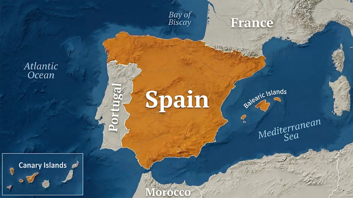
The Kingdom of Spain occupies most of the Iberian Peninsula in south-western Europe.
Portugal occupies the peninsula’s western part, while France lies beyond the Pyrenees towards the north-east.
Madrid is Spain’s centrally located capital and the country’s largest metropolitan centre by population.
A short chronological history
- Ancient Iberian and Celtic communities lived across the peninsula.
- Rome gradually conquered the region and called it Hispania.
- Visigothic rulers controlled much of Hispania after western Roman rule ended.
- Muslim forces entered the peninsula during 711 and formed Al-Andalus.
- Christian kingdoms expanded southwards over several following centuries.
- Granada, the last Muslim kingdom, fell during 1492.
- Columbus reached the Americas under Spanish royal sponsorship that year.
- Spain later built a large global empire under Habsburg and Bourbon monarchs.
- The Spanish Civil War lasted from 1936 until 1939.
- Francisco Franco then ruled Spain until his death during 1975.
- The 1978 Constitution established today’s democratic constitutional order.
- Spain joined the European Communities, today’s European Union, during 1986.
Political system
Spain is a parliamentary monarchy under its 1978 Constitution.
The monarch serves as head of state, while the prime minister leads the elected government.
Spain is a unitary state with extensive regional autonomy across 17 communities and two autonomous cities.
Those two autonomous cities are Ceuta and Melilla, both located on the North African coast.
Location and boundaries
| Direction | Neighbouring feature |
|---|---|
| West | Portugal and the Atlantic Ocean lie towards the west. |
| North | The Bay of Biscay, called the Cantabrian Sea locally, lies north. |
| North-east | France and Andorra lie across or within the Pyrenees. |
| East and south-east | The Mediterranean Sea borders the peninsula. |
| Far south | Gibraltar forms a small British Overseas Territory beside Spain. |
The Strait of Gibraltar separates southern Spain from Morocco and links the Atlantic with the Mediterranean.
Islands and territories
- The Balearic Islands lie within the western Mediterranean Sea.
- The Canary Islands lie in the Atlantic, near north-western Africa.
- Ceuta and Melilla are autonomous Spanish cities in North Africa.
- Several smaller islands and rocks also form Spanish territory.
Relief and major mountains
A large and elevated central plateau called the Meseta Central dominates much of mainland Spain.
The Pyrenees form a major mountain barrier along much of the land boundary between Spain and France.
The high Sierra Nevada range rises in southern Spain, relatively near the Mediterranean coast.
Mount Teide reaches 3,718 metres on Tenerife in the Canary Islands.
It is Spain’s highest point and an active volcanic structure within the Canary Islands hotspot system.
Mulhacén reaches 3,478 metres and is mainland Spain’s highest point.
Important rivers
| River | Important fact |
|---|---|
| Tagus, called Tajo in Spain | It is the Iberian Peninsula’s longest river and enters Portugal. |
| Ebro | It is the longest river flowing entirely within Spain. |
| Douro, called Duero in Spain | It flows westwards through Spain and Portugal. |
| Guadiana | It forms parts of the Spanish-Portuguese boundary. |
| Guadalquivir | It flows through Andalusia and reaches the Atlantic. |
Spain within European institutions
- Spain joined the European Union’s predecessor on 1 January 1986.
- It joined the Schengen passport-free area on 26 March 1995.
- It became a founding euro-area member on 1 January 1999.
- The country covers 505,983 square kilometres.
- Its official 2025 population estimate was 49,077,984.
Important natural distinction
Spain’s official tourism authority says it has more United Nations biosphere reserves than any other country.
These reserves combine biodiversity conservation with sustainable human activity.
How did the July wildfires become so dangerous?
Every wildfire needs heat, fuel and oxygen, while removing any one element can stop continued combustion.
Long heat and drought dry grass, shrubs and trees before ignition.
Strong winds then push flames and carry burning material ahead.
Steep slopes can speed uphill fire movement because rising heat preheats vegetation.
Homes built near forests create a dangerous wildland–urban interface where evacuation becomes especially difficult.
Climate connection
A warmer climate increases the frequency and intensity of extreme heat across the already dry Mediterranean region.
It can also lengthen periods when vegetation remains dry and flammable.
Every individual ignition still requires investigation because lightning, accidents or deliberate human actions may start fires.
Conclusion
Spain’s geography creates great diversity, but hotter and drier summers increasingly complicate wildfire management.