

Why in news?
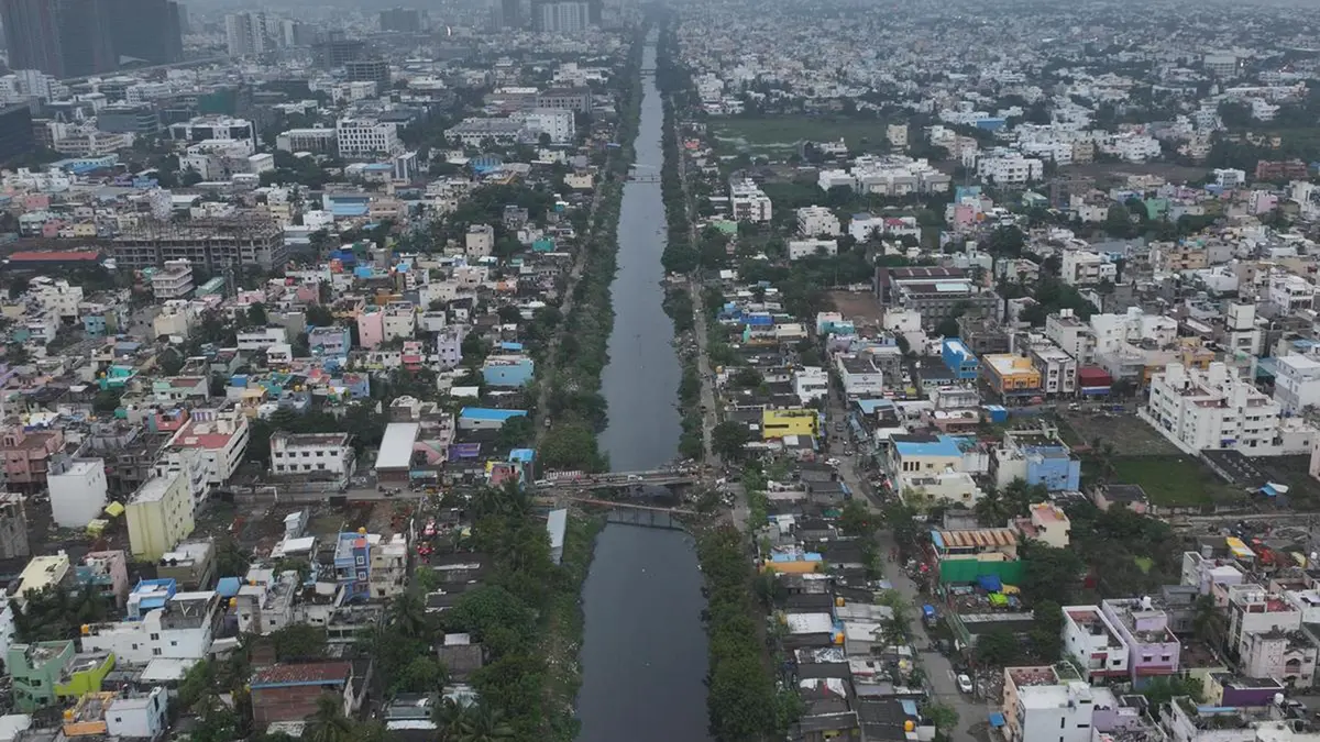
The Tamil Nadu government is examining a ₹876.35-crore proposal for central Chennai. It covers 7.2 kilometres of the Buckingham Canal. The stretch runs from Napier Bridge to the Adyar River. The plan considers boats and commercial activity, but major sewage and rehabilitation problems remain.
The proposal under examination
A Detailed Project Report was prepared by Tamil Nadu Water Investment Company Limited. It proposes passenger boats, cargo movement and floating restaurants. Reports also describe electric vessels and improved public spaces. These elements remain proposals and are not completed facilities.
The selected stretch crosses a dense part of Chennai. It runs beside transport infrastructure and established settlements. Low bridges and Mass Rapid Transit System pillars obstruct movement at several points. Dredging alone cannot solve these structural limits.
A canal built in stages
The waterway began as a smaller private canal in the early nineteenth century. Basil Cochrane developed an initial Chennai–Ennore stretch around 1806. It later came under government control and expanded north and south. The name Buckingham Canal appeared during the late nineteenth century.
The broader canal runs nearly parallel to India’s Coromandel Coast. It connects stretches in Andhra Pradesh and Tamil Nadu. Inland Waterways Authority material places the historic canal system at about 448 kilometres. Other modern descriptions round the figure to about 450 kilometres.
The system once moved salt, fuel, fish and other bulky goods. Irrigation canals linked it with the Krishna and Godavari river systems. Road and rail transport later reduced its commercial role. Sewage, silt and encroachment then damaged many urban sections.
Geographic and legal setting
The canal follows the Bay of Bengal side of southern India. Northern reaches pass coastal lagoons and low plains in Andhra Pradesh. The Chennai section crosses a heavily built coastal city. Southern reaches continue towards Marakkanam and the Kaluvelly wetland system.
Buckingham Canal forms part of National Waterway 4. That waterway includes linked canals and sections of the Krishna and Godavari. The National Waterways Act, 2016 continued its legal national-waterway status. Development for navigation is coordinated through the Inland Waterways Authority of India.
In February 2026, the Union government confirmed a new feasibility review. The Authority sanctioned ₹5.23 crore to update the detailed report for National Waterway 4. That exercise is distinct from Tamil Nadu’s reported ₹876.35-crore Chennai proposal.
The central difficulty is sewage
The state report identifies nearly 50 million litres of daily sewage entering this stretch. Navigation cannot remain safe or attractive without interception and treatment. Moving polluted water would only hide the underlying failure. Water-quality targets should therefore precede tourism operations.
Solid waste and silt also reduce carrying capacity. Regular maintenance is essential after any one-time cleaning. Connections between drains, pumping stations and treatment plants need mapping. Public reporting should show whether pollution loads actually fall.
Flood management and settlement rights
The canal is part of Chennai’s wider drainage network. Any redesign must preserve storm-water movement during intense rain. Jetties, restaurants or narrowed sections could create new obstructions. Hydraulic modelling should test each structure under severe rainfall conditions.
The project report mentions rehabilitation for nearly 5,000 families. That estimate requires transparent verification. Residents need lawful notice, consultation and suitable resettlement before displacement. Housing should preserve access to work, schools and transport.
Restoration can improve mobility and public space only when these issues are solved together. A boat service cannot substitute for sewer reform. Beautification cannot substitute for flood capacity. Rehabilitation cannot be treated as a minor engineering cost.
Three objectives must align
Navigation, pollution control and flood management must share one design. Each affects the canal’s width, water level and structures. Social rehabilitation is a fourth essential part of the same project.
Conclusion
The proposal has returned a neglected waterway to public attention. Its historic route offers real mobility and ecological possibilities. Yet Chennai’s central stretch is also a sewer, drain and lived urban space. Restoration must begin with clean water and flood safety. Boats should follow proven rehabilitation, not precede it.